Planning, Design and Construction of New Drainage Facilities
Drainage Master Plan Review Study
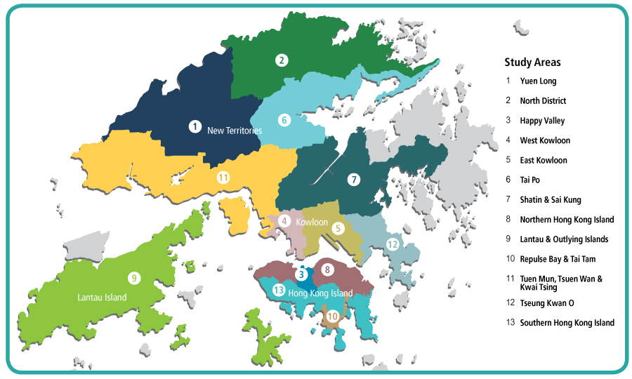
To tie in with Hong Kong’s future development and adapt to rising challenges of climate change, we have conducted DMP review studies and drainage studies on the whole territory of Hong Kong. The review studies of DMPs for Yuen Long and North District and the drainage study for Happy Valley were completed in 2011, whereas the improvement works at Happy Valley have been fully commissioned since 2017. The studies for West Kowloon and East Kowloon were also completed in 2015 and the proposed improvement works are under planning. The review studies for Tai Po, Shatin and Sai Kung and the review study for Northern Hong Kong Island were also completed in 2017 and 2019 respectively.
Current Progress
At present, the improvement works proposed on the studies for Yuen Long and North District in the New Territories are under the design stage. The proposed improvement works for West Kowloon and East Kowloon are also under the planning stage. The investigation of the proposed improvement works in Sha Tin and Sai Kung commenced in 2019 while the investigation of the proposed improvement works in Tai Po and Hong Kong Island is targeted to commence in 2020. The two DMP review studies of Lantau and Outlying Islands, and Tuen Mun, Tsuen Wan and Kwai Tsing, and the drainage study for Repulse Bay and Tai Tam, are currently underway.
Kai Tak River Improvement Works (upstream and midstream sections)
To improve the flood protection levels of East Kowloon, the improvement works of reconstructing and rehabilitating the 1.1 kilometres section of the Kai Tak River from Po Kong Village Road to Prince Edward Road East have been completed. The works involved deepening of the riverbed and constructing a 400 metres long box culvert underneath Choi Hung Road.。
Kai Tak River before the improvement works
Kai Tak River after the improvement works
Current Progress
The improvement works commenced in stages since October 2011 and were completed in June 2018. The project cost is about $2.8 billion. At present, Kai Tak River meets the latest flood prevention design standards, alleviating the flood risks in Wong Tai Sin and San Po Kong areas.
DSD has also taken this opportunity to inject various greening and ecological elements into Kai Tak River, thus revitalising it into an urban green river corridor. The living environment has been improved through enhancing the townscape of the area, provisioning of a scenic and leisure place for enjoyment of the public, as well as fostering closer connection between river and adjacent areas.
West Kowloon Drainage Improvement – Inter-reservoirs Transfer Scheme
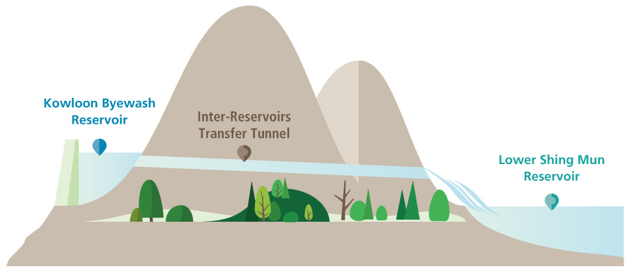
In an attempt to enhance the flood prevention capacity of West Kowloon to cope with the challenges posed by climate change, we are constructing a water tunnel with a total length of about 2.8 kilometres connecting Kowloon Byewash Reservoir and Lower Shing Mun Reservoir, which will transfer the surface runoff collected from the Kowloon group of reservoirs to Lower Shing Mun Reservoir. The Inter-reservoirs Transfer Scheme will generate an annual additional fresh water yield of about 3.4 million cubic metres with a view to achieving dual purposes in flood protection and water conservation.
Illustration of Inter-reservoirs Transfer Scheme
Current Progress
The project commenced in February 2019 and is scheduled for completion in 2022. The estimated project cost is about $1.22 billion.
Illustration of Inter-reservoirs Transfer Scheme
Revitalisation of Tsui Ping River
Situated right at the heart of Kwun Tong, Tsui Ping River is a nullah running along Tsui Ping Road and King Yip Street. It is set in close proximity to residential, commercial and industrial areas. Given its unique waterscape, Tsui Ping River is well-positioned to become a valuable urban riverside leisure space for public enjoyment. In addition to enhancing flood prevention capacity, we are transforming the existing nullah into Tsui Ping River through environmental, ecological and scenic enhancement. The project also beautifies adjoining pavements as well as improves connectivity and walkability by providing riverside walkways and landscaped decks. We aspire to turn the existing nullah into a new landmark where the public can enjoy the river view and leisure activities.
Current Progress
We conducted the Stage 2 Public Engagement exercise in mid-2018 to collect public views on the project and the latest revitalisation plan. The detailed design of the project was substantially completed in early 2019.^
Photomontage of the revitalised Tsui Ping River
^ Subject to funding approval, the works will commence in the early 2020 and target for completion in early 2024. The estimated project cost is about $1.76 billion.
The works under the revitalisation of Tsui Ping River comprise the following:
-
Revitalisation of the existing nullah through the provision of attractive waterscape design and water features
-
Provision of landscaped decks and amenity public space above the river
-
Provision of walkways along/across the river to enhance connectivity in order to transform Tsui Ping River into a green river corridor in the community
-
Modification of the existing footbridge across Lei Yue Mun Road
-
Beautification of streets adjacent to Tsui Ping River


